


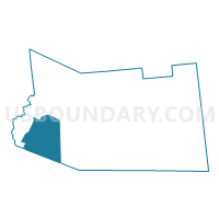
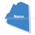
Voting District 100001, Fulton County, New York
About
Outline

Summary
| Unique Area Identifier | 627293 |
| Name | Voting District 100001 |
| County | Fulton County |
| State | New York |
| Area (square miles) | 37.25 |
| Land Area (square miles) | 37.21 |
| Water Area (square miles) | 0.04 |
| % of Land Area | 99.89 |
| % of Water Area | 0.11 |
| Latitude of the Internal Point | 43.06492730 |
| Longtitude of the Internal Point | -74.65988050 |
Maps


Graphs
Select a template below for downloading or customizing gragh for Voting District 100001, Fulton County, New York


Neighbors
Neighoring Voting District (by Name) Neighboring Voting District on the Map
- Voting District 040001, Fulton County, NY
- Voting District 040002, Fulton County, NY
- Voting District 100002, Fulton County, NY
- Voting District 110001, Montgomery County, NY
- Voting District 110002, Montgomery County, NY
- Voting District 120001, Fulton County, NY
Top 10 Neighboring County Subdivision (by Population) Neighboring County Subdivision on the Map
- St. Johnsville town, Montgomery County, NY (2,631)
- Oppenheim town, Fulton County, NY (1,924)
- Ephratah town, Fulton County, NY (1,682)
- Stratford town, Fulton County, NY (610)
Top 10 Neighboring Unified School District (by Population) Neighboring Unified School District on the Map
- Dolgeville Central School District, NY (5,362)
- St. Johnsville Central School District, NY (3,324)
- Oppenheim-Ephratah Central School District, NY (2,725)